Uttarkashi Travel Guide
The comfortable months are roughly May to mid-June and September to October , built around the Gangotri and Yamunotri yatra. The monsoon brings landslides and is best avoided.
When to visit Uttarkashi, and the Char Dham season
The comfortable months are roughly May to mid-June and September to October, built around the Gangotri and Yamunotri yatra. The monsoon brings landslides and is best avoided.
- May to mid-June: the prime windowPleasant by day, the snow melting off the high country and the Gangotri road usually at its clearest, this is the classic window for the yatra and for reaching the source of the Ganga. It is also the busiest, so register and book ahead.
- September to October: clear and quieterOnce the monsoon recedes the skies clear, the crowds thin and the air turns crisp, which many regulars feel is the loveliest time on this route. Carry warm layers, as nights are cold and Gangotri sits high.
- Late June to August: monsoon, best avoidedHeavy rain brings frequent landslides and rockfalls on the Uttarkashi to Gangotri road. Travel can be slow, blocked or genuinely risky, so most seasoned travellers keep clear of the high yatra route in these weeks.
- December to March: snow and the high town closedGangotri's temple is shut for winter and the high road is snowbound, but this is prime season for the snow treks near Uttarkashi, above all Dayara Bugyal from Raithal, which turns into a wide field of snow.
Gangotri and Yamunotri open on Akshaya Tritiya, which in 2026 fell on about 19 April; Gangotri is expected to close for winter around 10 to 11 November 2026 in the Diwali and Bhai Dooj period. These dates shift every year with the Hindu calendar, and many websites copy old dates as if they were fixed. Treat the closing date as expected, not confirmed, and reconfirm the official portal-opening and closing dates on the Uttarakhand tourism registration portal before you book flights or rooms.
How to reach Uttarkashi
Uttarkashi has no airport or railway of its own. Almost everyone comes by road from Rishikesh or Dehradun, then drives on to Gangotri.
- From Rishikesh, the usual gatewayRishikesh is the nearest railhead and the start of the mountain drive, about 145 to 170 km depending on the route, roughly 6 to 8 hours by car or bus via Chamba, New Tehri and Dharasu on National Highway 34. Distances quoted online vary, so do not lock a single figure.
- From Dehradun and Jolly Grant airportDehradun is about 144 km away, roughly 5 to 7 hours, and its Jolly Grant airport, about 160 km from Uttarkashi, is the nearest airport with regular flights. There are no flights into Uttarkashi itself.
- From Haridwar and DelhiHaridwar is roughly 165 to 190 km depending on route. Delhi is about 431 km, a long day of 9 to 11 hours, so most travellers break the run at Rishikesh or Haridwar and start the mountain section fresh in the morning.
- On to GangotriFrom Uttarkashi, Gangotri is about 99 to 100 km further up the Bhagirathi on NH-34, roughly 3 to 4 hours of curving mountain road. Uttarkashi is the natural overnight stop before the final climb to the source.
- Buses and shared jeepsState buses (Uttarakhand Transport) and the long-running GMOU operator run from Rishikesh into the Garhwal hills, and shared jeeps and Sumos cover the hops between hill towns. They are economical but slower with stops, so allow extra time.
- Hire a mountain-experienced driverThe hill roads are narrow, with sharp blind turns and stretches prone to rockfall. A driver used to these mountains is worth far more than a cheaper one who is not, and we can arrange a car and an experienced driver for the whole route.
Fly into Delhi, then take a train or drive to Rishikesh or Haridwar, and continue by road to Uttarkashi. There are no international flights anywhere near, and the last leg is mountain road, so build in a buffer day.
Fly into Delhi or Dehradun (Jolly Grant), then drive from Dehradun or Rishikesh into the hills. Dehradun's airport is the closest practical air gateway, still about 160 km out.
Take a train to Rishikesh or Dehradun, then a bus, shared jeep or taxi up to Uttarkashi. The Rishikesh railhead and the Char Dham bus routes are the simplest way in.
The mini-Kashi temples, the ghats, and NIM
Uttarkashi is the Kashi of the north: the Vishwanath temple, the Shakti trishul, the Bhagirathi ghats, and India's famous mountaineering institute.
- Kashi Vishwanath TempleThe town's central shrine to Lord Shiva, and the reason it is called Uttar Kashi, the Kashi of the north. The Shiva linga here is notable for leaning to one side. It is the heart of the old town and an easy walk from the ghats. Specific daily timings vary between sources, so check locally on the day.
- The Shakti Temple and its trishulDirectly opposite the Vishwanath Temple stands the Shakti Temple, home to a very large trident, a trishul believed to be roughly 6 m, about 19 to 20 feet, tall and treated as extremely ancient. The exact age and inscriptions repeated online are not reliably documented, so enjoy the tradition without taking the dates as fact.
- The Bhagirathi ghatsUttarkashi is deliberately laid out as a mini-Kashi, with riverside ghats on the Bhagirathi and a Manikarnika or Kedar (Mukti) ghat where cremations are held. It is a working pilgrim town, not a show, so watch quietly and respectfully. This is a different, much smaller ghat than the famous Manikarnika Ghat of Varanasi.
- Nehru Institute of Mountaineering (NIM)About 3 km from town, NIM is one of India's premier mountaineering schools, founded in 1965, with a Himalaya Museum of expedition history and gear. Visitors can usually see the campus and museum, though exact hours and any fee are best confirmed locally, as they are not clearly published online.
Uttarkashi is a deeply religious place and a cremation ghat sits in the middle of it. Cover shoulders and knees near the temples and ghats, remove shoes where asked, do not photograph cremations or people at prayer without consent, and remember the whole yatra route is vegetarian and best treated as alcohol-free. A little respect goes a long way in a town where pilgrims have come for centuries.
Uttarkashi as the gateway to Gangotri and Yamunotri
This is where you become ready for the high pilgrimage: register, acclimatise, draw cash and sleep, then drive up to Gangotri, with the Yamunotri route branching off the same circuit.
- Gangotri, the source shrineGangotri is one of the four Char Dham of Uttarakhand and the spiritual source of the Ganga, about 99 to 100 km and 3 to 4 hours up the Bhagirathi from Uttarkashi. The temple opens for the season on Akshaya Tritiya and closes for winter around Diwali. Uttarkashi is where most pilgrims sleep the night before.
- Yamunotri, the other western dhamYamunotri, the source shrine of the Yamuna, opens the same day as Gangotri and sits on the same western Char Dham circuit, reached via Barkot. Its final approach is a walk of a few kilometres from Janki Chatti, by foot, pony or palki, which matters if you are travelling with elders.
- Gaumukh, the glacier snout, beyond GangotriFor trekkers, Gaumukh, the snout of the Gangotri glacier where the Bhagirathi emerges, lies about 18 km on foot beyond Gangotri and needs a forest department permit. It is a serious high-altitude walk, not a casual add-on, and is covered in the treks section below.
- Why you base here, not higher upUttarkashi at about 1,158 m has the hospitals, ATMs, registration help, fuel and choice of stays that the small high villages do not. Spending a night here lets your body begin to adjust before Gangotri at about 3,100 m, and it is far easier to sort logistics here than at the source.
On a classic western Char Dham plan, travellers do Yamunotri first and Gangotri next, with Uttarkashi as the hinge between them, before crossing to Kedarnath and Badrinath. If you only have time for one, Gangotri is the easier road approach and the more straightforward darshan, while Yamunotri asks for the final uphill walk. Either way, Uttarkashi is the town where the high journey is planned and rested.
Dayara Bugyal, Dodital and Gaumukh: the treks from Uttarkashi
Uttarkashi is a real trekking base. Here are the three big walks, their seasons, base villages and permits, set side by side so you can choose.
- Dayara Bugyal: the meadow and snow trekA high meadow at about 3,750 m in the Gangotri range, trekked from Raithal or Barsu over roughly 4 to 5 days. Green and flower-filled in April to June and September to November, and snow-covered from about December to March, when it becomes one of Uttarakhand's best beginner-friendly snow treks. Raithal is the more scenic start.
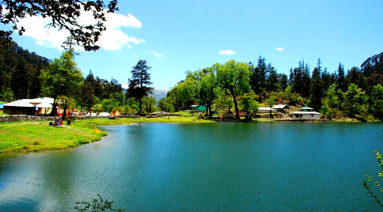
- Dodital: the trout lake trekA freshwater lake at about 3,024 m reached from Sangam Chatti, about 15 km from Uttarkashi, on a trek of roughly 22 km one way usually done over about 5 days. The lake is associated with Himalayan trout and makes a gentler, greener forest walk than the open high meadows.
- Gaumukh and Tapovan: to the sourceFrom Gangotri, Gaumukh, the snout of the Gangotri glacier and the actual source of the Bhagirathi, is about 18 km on foot, with Tapovan a few kilometres further. This is a serious high-altitude trek that needs a forest department permit and good acclimatisation, not a day stroll. Go with a registered operator and proper gear.
- Kedarkantha, from the same districtThe popular winter summit trek to Kedarkantha, around 3,800 m, starts from Sankri in the wider Uttarkashi district, usually reached via Dehradun. It is a 5-day-ish snow climb in December to March and a separate base from Uttarkashi town, but worth knowing if winter snow is your aim.
The Gaumukh trek requires a forest department permit, and all of these high walks demand real acclimatisation and, for most travellers, a registered local operator with a guide. Do not attempt Gaumukh or the high meadows on a whim straight off a long drive. Build in acclimatisation days at Uttarkashi, carry warm and waterproof layers in every season, and treat the mountains and the weather with respect. Booking a vetted trek operator is far safer than going alone.
Harsil valley and the Gartang Gali staircase
Up the Gangotri road, the apple valley of Harsil and the restored cliff-staircase of Gartang Gali are two quieter sights worth the extra time.
- Harsil valley and its applesA green valley on the Bhagirathi on the way up to Gangotri, Harsil is known for its apple orchards, the legacy of a British settler, and its quiet alpine calm. It makes a gentle, scenic halt that most yatra traffic rushes past. Confirm the exact distance up the Gangotri road locally, as published figures vary.
- Gartang Gali, the cliff staircaseA historic wooden staircase and hanging gallery carved into a vertical cliff above the Jadh Ganga gorge, on the old Indo-Tibetan trade route in the Nelong area. It fell into disuse after the 1962 India-China war and reopened to visitors in 2021 after decades, with around 136 m of restored wooden walkway.
- Why these reward the detourMost travellers see only the temple-to-temple line and miss the quieter Garhwal beyond it. Harsil's orchards and Gartang Gali's vertigo-inducing staircase are the kind of detail that turns a tick-the-box yatra into a real journey, if you have the extra day and the road is open.
- Check access before you goThe Nelong and Gartang Gali area is close to a sensitive border zone, so access rules and entry caps can change. Confirm current opening, any visitor limits and the road condition with your operator or the local authorities before planning a day around it.
Where to stay in Uttarkashi, and how many nights
Stay in Uttarkashi town to be near temples, ATMs and the bus stand, or push up to Harsil or Gangotri for the high country. One or two nights here suits most plans.
- Uttarkashi town: the practical baseThe town has the widest choice of stays, the temples, the ghats, ATMs, fuel and the bus and taxi stand. It is the natural place to acclimatise and sort logistics before going higher. Best for first-timers and anyone doing the yatra at a sensible pace.
- GMVN rest housesGarhwal Mandal Vikas Nigam, the state tourism body, runs tourist rest houses at Uttarkashi, Harsil and Gangotri, bookable on gmvnonline.com. The Uttarkashi rest house is commonly quoted from about 1,000 rupees a night, with a pure-vegetarian restaurant on site. Confirm current tariffs on the official site at booking.
- Private guesthouses, dharamshalas and hotelsBeyond GMVN there are private budget guesthouses, simple dharamshalas and a few mid-range hotels in town and up at Gangotri. Rooms are basic and prices rise and fill fast in peak yatra season, so book ahead for May, June and the September window.
- How many nightsFor the temples, NIM and an acclimatisation night, one or two nights in Uttarkashi is enough. Add nights for Gangotri and Yamunotri, and several more for any of the treks. A whole western Char Dham loop with Yamunotri and Gangotri usually runs about 5 to 6 days from a hill base.
In May, June and the post-monsoon September window, the yatra fills the limited rooms at Uttarkashi, Harsil and Gangotri quickly, and prices climb. Book your nights well ahead, keep a backup option, and remember that the higher villages have far fewer beds and almost no walk-in choice. Basing the night before Gangotri at Uttarkashi is both the safer altitude choice and the easier booking.
Uttarkashi and Gangotri costs and a realistic budget
The region is moderate on the wallet, but the road legs and peak-season rooms add up. Here is what the main things cost so you can plan and avoid being overcharged.
- A rough trip budgetA 4 to 5 day Gangotri trip from Delhi is often budgeted at about 7,000 to 11,000 rupees per person on a tight budget and about 13,500 to 21,000 rupees mid-range, covering transport, simple stays and food. Treks and longer Char Dham loops cost more, and peak season pushes everything up.
- Taxi fares to GangotriA private taxi from Uttarkashi to Gangotri is commonly quoted from about 1,089 to 1,100 rupees for a sedan, about 1,485 to 1,500 rupees for an SUV and about 2,485 rupees for an Innova one way for the roughly 99 km run. Shared jeeps and buses are cheaper but slower with stops. Agree the fare before you set off.
- Rooms and foodGMVN and budget rooms in Uttarkashi start from about 1,000 rupees a night off-peak, more at Gangotri and in season. Food on the route is simple pure-vegetarian fare, with a day's meals at Gangotri often around 300 to 500 rupees. The registration itself is free.
- Carry cash, you will need itThere is no ATM at Gangotri and signal is patchy above Uttarkashi, so cards and UPI cannot be relied on higher up. Draw enough cash at Uttarkashi or Rishikesh for the whole high leg, and keep small notes for buses, dhabas and tips.
On this route the single best habit is to settle two things at Uttarkashi before you climb: agree your taxi fare in advance, and draw all the cash you will need for Gangotri and above. There is no ATM at the source, signal drops out, and a fare argued at the top with no alternative transport is the only common friction on an otherwise gentle trip. Sort both in town and the rest of the journey runs smooth.
Practical logistics: registration, food, money and signal
The small things that make a Uttarkashi and Gangotri trip smooth, from the mandatory free registration to ATMs, networks and the vegetarian route.
- Register first, for freeChar Dham registration is mandatory and, as of this update, free, including for Gangotri and Yamunotri. Do it on the official portal at registrationandtouristcare.uk.gov.in, the Tourist Care Uttarakhand app, or by sending Yatra on WhatsApp to the official number. A single registration can cover all four dhams, and a daily pilgrim cap per shrine is enforced, so register early. Authorities have at times floated a token charge to curb fake bookings, but the official registration has stayed free, so reconfirm on the official portal and never pay an agent who claims to charge for it.
- Cash, ATMs and cardsUttarkashi has ATMs and is the place to draw cash. There is no ATM at Gangotri, and above town the signal weakens, so cards and UPI are unreliable higher up. Carry enough cash for the whole high leg and keep small notes for buses and dhabas.
- Mobile signal and networksAround Gangotri, BSNL tends to be the most reliable network, while Jio and Airtel work intermittently in Uttarkashi and tend to drop out higher up. Download offline maps and tell someone your plan, because connectivity cannot be assumed on the high road.
- Food, water and the vegetarian ruleThe whole yatra route is pure-vegetarian, and most travellers keep it alcohol-free too. Food is simple home-style cooking; carry bottled or filtered water, take the usual care with road-side food, and pack dry fruit and snacks for the long drives and any trek.
Safety, landslides, altitude and staying well
Uttarkashi and Gangotri are rewarding but mountainous and weather-exposed. The two things to respect are the road in the rains and the altitude up high.
- The road and landslidesThe Uttarkashi to Gangotri road on NH-34 follows the Bhagirathi and passes landslide-prone, rockfall-prone sections, worst after heavy rain. Avoid the monsoon weeks of late June to August on this route, start early, never push on through a storm, and accept that delays for road-clearing are part of mountain travel here.
- Altitude at GangotriGangotri sits at about 3,100 m, high enough for mild altitude sickness. Night-halt and acclimatise at Uttarkashi at about 1,158 m first, drink plenty of water, avoid alcohol and heavy exertion on the first high day, and ascend gradually. Anyone with heart or breathing conditions, and most seniors, should take this slowly and consult a doctor before the trip.
- An honest word on the region's exposureThis is geologically young, landslide-prone Himalaya. The Silkyara-Barkot tunnel near Uttarkashi collapsed on 12 November 2023, trapping 41 workers, all of whom were rescued after 17 days on 28 November 2023. It is a reminder, not a reason to stay away: plan for the weather, keep buffer days, and follow official advisories.
- Health basics and helpCarry a basic medical kit, any personal medicines, sun protection and warm layers for every season. Uttarkashi has the area's hospital and pharmacies, so stock up in town; the small high villages have little. In an emergency, your operator and the GMVN rest houses can usually help reach medical care faster than going it alone.
The yatra route is busy with pilgrims and families in season and is generally calm, with the real risks being the road and the altitude rather than crime. Solo travellers and women travelling alone usually find it manageable with standard precautions: travel the high legs in daylight, keep someone informed of your plan, prefer registered transport and operators, and do not trek the high routes alone. Off-season, when the road empties and signal drops, go with a guide or a group.
Uttarkashi for every kind of traveller, and on access
The town and its high country suit very different visitors. Here is what it offers each, and the one tip that matters, including how an older pilgrim manages the altitude.
- PilgrimsThis is the base of the western Char Dham, the town where you register, rest and start the climb to the Ganga's source. Plan your darshan around the temple opening dates, register first, and give yourself an acclimatisation night before Gangotri.
- Senior travellers and on accessibilityVery doable with care. The challenge is altitude and the road, not the town. Acclimatise at Uttarkashi, ascend slowly, keep medicines and warm clothing handy, and remember Yamunotri ends in an uphill walk for which ponies and palkis are available. Anyone with heart or breathing issues should consult a doctor and take the high legs gently.
- Families with childrenManageable and rewarding, with the temples, the river and the apple valley of Harsil. Keep children hydrated, warm and not over-exerted at altitude, build in rest days, and skip the hardest high treks with young ones.
- Trekkers and backpackersA genuine trekking hub: Dayara Bugyal, Dodital and the serious Gaumukh-Tapovan walk all start from or near here. Pick your season, sort the Gaumukh permit, and go with a registered operator and proper gear rather than improvising.
- Solo travellersGenerally calm and busy with pilgrims in season. Travel the high legs in daylight, use registered transport, keep someone informed, and do not trek the high routes alone. Off-season the road empties and connectivity drops, so join a group or hire a guide.
- PhotographersThe Bhagirathi and its ghats, the mini-Kashi temples, the apple valley, Gartang Gali's cliff staircase and the high meadows reward an early start and patience. Ask before photographing people at prayer, and never photograph the cremation ghat.
A suggested Uttarkashi and Gangotri itinerary
How to shape a few unhurried days so you acclimatise properly, see the town, and reach the source without rushing the mountain road.
- Day one: up from Rishikesh, settle in UttarkashiStart early from Rishikesh for the 6 to 8 hour mountain drive, arrive in Uttarkashi by afternoon, and let the day end gently. Walk to the Vishwanath and Shakti temples and the ghats, and let your body begin to adjust to the height.
- Day two: Gangotri and back, or stay upDrive the 3 to 4 hours up to Gangotri for darshan at the source, then either return to Uttarkashi to sleep lower, which is kinder on the body, or stay the night at Gangotri if you want an unhurried morning at the temple.
- Add Yamunotri and the full circuitTo pair Gangotri with Yamunotri on the western Char Dham, add two or three days via Barkot and Janki Chatti, remembering Yamunotri's final uphill walk. A complete western loop with both shrines usually runs about 5 to 6 days.
- Add a trekIf you have come for the mountains, give Dayara Bugyal about 4 to 5 days or Dodital about 5 days from their base villages, or plan the serious Gaumukh-Tapovan walk with permits and acclimatisation. Do not bolt a high trek onto a tight yatra schedule.
The single thing that breaks a Gangotri plan is rushing height and ignoring the road. Spend a night at Uttarkashi before going to Gangotri at about 3,100 m, keep buffer days for landslide delays in any season and especially after rain, and start each mountain leg early so you are not driving the high road in the dark or a storm. A day in hand is worth more than a tight schedule on this route.
The real questions travellers ask about Uttarkashi
Straight answers to the questions that come up again and again on traveller forums, so you arrive already knowing the score.
- Is Char Dham registration really mandatory and free?Yes. For 2026 it is compulsory and free, including for Gangotri and Yamunotri, on the official portal, the Tourist Care app or by WhatsApp, and one registration can cover all four dhams. Anyone charging you for the official registration is not official.
- How do I get from Uttarkashi to Gangotri?By private taxi from about 1,089 rupees for a sedan, by SUV from about 1,485 rupees, or by cheaper shared jeep or state bus, for the roughly 99 to 100 km run of 3 to 4 hours. Agree any taxi fare before you set off, and start early.
- Is there a helicopter to Gangotri?No regular passenger helicopter lands at Gangotri the way one shuttles to Kedarnath. Gangotri and Yamunotri are reached by road even within full Char Dham helicopter packages, so plan on the mountain drive.
- Is there an ATM at Gangotri, and which network works?There is no ATM at Gangotri, so draw cash at Uttarkashi or Rishikesh. Around Gangotri, BSNL tends to be the most reliable network, with Jio and Airtel intermittent, so do not count on signal or cards higher up.
- How many days, and how do I avoid altitude sickness?Give Gangotri at least an overnight at Uttarkashi to acclimatise, then a day up and back; a western loop with Yamunotri runs about 5 to 6 days. Ascend gradually, hydrate, avoid alcohol and over-exertion on the first high day, and take it slowly if you have any heart or breathing condition.
- How fast can I trek Dayara Bugyal?Dayara Bugyal is a beginner-friendly meadow at about 3,750 m, usually walked over about 4 to 5 days from Raithal or Barsu. It can be done faster by the very fit, but the meadow and the snow are the point, so most travellers take it gently.
Planning Uttarkashi and Gangotri from abroad
Uttarkashi is the honest base camp for the source of the Ganga. A little preparation on registration, altitude and cash makes the high pilgrimage easy to handle.
- Register before you go, it is freeChar Dham registration is mandatory and free, including for Gangotri and Yamunotri, on the official Uttarakhand portal, the Tourist Care app or by WhatsApp. Do it in advance, keep the confirmation handy, and ignore anyone abroad or on the road who asks you to pay for the official registration.
- Respect the altitudeGangotri sits at about 3,100 m. Fly in, rest at Rishikesh, and acclimatise a night at Uttarkashi at about 1,158 m before going up. Hydrate, ascend slowly, and if you have any heart or lung condition, see a doctor before the trip. This is high Himalaya, not a city sightseeing day.
- Carry cash and expect weak signalThere is no ATM at Gangotri and the mobile signal thins out above Uttarkashi, with BSNL the most reliable network up high. Draw enough cash at Rishikesh or Uttarkashi, download offline maps, and do not rely on cards, UPI or live data above town.
- Slot it into a Rishikesh and Himalaya tripFly into Delhi, take in Rishikesh and Haridwar, then go up to Uttarkashi and Gangotri, and on to the rest of the Char Dham if you have time. It is the soulful high chapter of a north India trip, and the road is the journey, so give it room.
Etiquette, timing and the route for foreign visitors
The practical and cultural basics an overseas traveller needs for a high pilgrimage town: holy-site etiquette, when to come, and how to handle the road.
- Holy-site etiquetteThis is a living pilgrimage town with a cremation ghat in its heart. Dress modestly, cover shoulders and knees near temples and ghats, remove shoes where asked, do not photograph cremations or people at prayer without consent, and keep the route vegetarian and effectively alcohol-free out of respect.
- Time your visit to the seasonCome in roughly May to mid-June or September to October for the clearest roads and the yatra in full flow, and avoid the monsoon weeks of late June to August when landslides close the high road. Reconfirm the official temple opening and closing dates before you book, as they move each year.
- Plan the road, not just the sightsThe mountain drives are long, narrow and weather-dependent, so hire an experienced driver, start each leg early, and keep buffer days. The road delays are part of the journey here, and a fixed flight home with no slack is the classic mistake on this route.
- Travel light, layer upPack warm and waterproof layers in every season, a basic medical kit and any personal medicines, sun protection for the high glare, and good walking shoes. Stock up in Rishikesh or Uttarkashi, because the small high villages carry very little.
Uttarkashi and Gangotri are an unusually meaningful introduction to the Himalaya: the source of India's holiest river, a genuine pilgrim town, and high country that asks you to slow down and respect the weather. Treat the road as part of the experience rather than a transfer, give the altitude time, register in advance, and many overseas visitors find this becomes the chapter of their India trip they remember most deeply.
Uttarkashi, the Varanasi of the Himalaya
Uttarkashi means the Kashi of the north, and the town is laid out as a deliberate echo of Varanasi on the plains. Where Kashi has the Ganga, Uttarkashi has the Bhagirathi, the prime headstream that becomes the Ganga; where Kashi has its Vishwanath temple to Lord Shiva, so does Uttarkashi, with the same Vishwanath dedication and a Shiva linga that famously leans to one side; and where Kashi has its Manikarnika cremation ghat, Uttarkashi has its own riverside Manikarnika or Kedar (Mukti) ghat where the dead are given to the river, far up in the mountains. Tradition ties the town to the sage Markandeya and to Shiva's protection of him, and holds that the Ganga herself was honoured here before her descent to the plains. The leaning linga, the great trishul of the Shakti Temple opposite, and the ghats below tell the same story as the city on the plains, transplanted to the high Himalaya as the gateway to the very source of the holy river.
Tour packages that visit Uttarkashi
Every journey below is private, hand-crafted and fully customizable. Tell us your dates and we tailor the itinerary, the pace and the priests or guides around you.