01
Tawang Monastery
Tawang
Founded 1680 to 1681, the largest Buddhist monastery in India
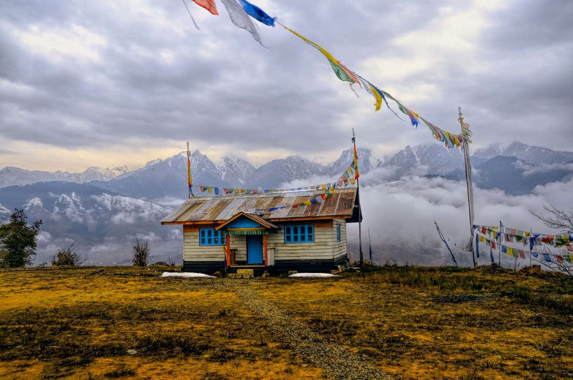
October to early December for clear skies, and March to May for milder days. December to February brings snow on Sela and frozen lakes, so roads may need chains. Avoid June to September, when landslides often block the Tawang road.
Overview
This Arunachal Pradesh tour package is 7 nights and 8 days. It starts in Guwahati and ends in Guwahati. You drive up the Tawang road through Bhalukpong, Bomdila and Dirang. You cross Sela Pass and stay three nights in Tawang. Then you come back down through Bomdila.
Most packages give Tawang one full day. We give you two, plus the evening you arrive. That spare time matters. Bum La needs a permit from the DC office and the army, and the office issues it only in working hours. Snow or a landslide can also take away a day. With three nights, you still see everything.
The climb is gentle on purpose. Bhalukpong is only about 213 m above the sea. Dirang is about 1,500 m. You sleep at both before you go to Tawang, and you go to Bum La, at about 4,600 m, only after two nights in Tawang. This order is the single most important thing for elders on this route.
This page is the whole-state guide. It also tells you how to add Ziro, the Ziro Festival of Music and the eastern circuit with Parshuram Kund, if you want a longer trip.
Yes. Every visitor needs a permit, and the type depends on your passport.
Apply at least a week before you travel, and never on the last day. Travellers on review sites warn that offices keep short hours on weekends and in the off-season. We check every name, date and ID number on your permit before you leave home.
Bum La is a pass on the India China border, about 37 km from Tawang town, at about 4,600 m (15,200 ft). The Indian Army maintains it. It is one of the official points where Indian and Chinese officers meet. In the 1962 war, the Chinese army came in through this route.
To go there, you need a special permit. You apply at the Office of the Deputy Commissioner in Tawang. The permit is then stamped at the army cantonment in Tawang town. Without that stamp, the army check posts will not let you pass. From 1 September 2025, the DC office also charges an entry fee when it issues the permit. Children under 12 are exempt. Please confirm the current rate on the official site or at the office.
The same permission covers Sangetsar lake, about 35 km north of Tawang. Our driver files your papers on the day you reach Tawang, so the permit is ready for Day 5. If the army closes the road for weather or duty, we keep the day for the lakes near town and try again the next morning. We cannot promise Bum La. The army decides, and it is right that the army decides.
Foreign passport holders, including OCI card holders, should not plan on Bum La. The official notes we have found speak only of Indian visitors, so please do not count on it.
Sela Pass sits at about 4,200 m, or about 13,700 ft, on the only road to Tawang. It stays under snow for much of the year. In the old days, heavy snow on Sela could cut Tawang off for days.
The Prime Minister opened the Sela Tunnel on 9 March 2024. The tunnel runs about 400 m below the pass. The Tawang district administration calls it an all-weather link between Guwahati and Tawang. It cuts the Dirang to Tawang road by about 10 km, and saves about an hour.
So you have two choices on Day 3. On a clear day, we take the old road over the top. You see Sela lake, the prayer flags and the snow at the pass. If the top is closed or the weather turns, the driver takes the tunnel. Either way, you reach Tawang.
In winter, the Tawang district administration asks drivers to fit non-skid chains on snow. It also warns visitors never to step on a frozen lake, as the ice may be thin.
The International Society of Travel Medicine says altitude sickness can start at about 2,500 m. On this trip, Bomdila is about 2,415 m, Tawang is about 3,000 m or more, Sela is about 4,200 m and Bum La is about 4,600 m. So yes, altitude is real here.
This plan climbs slowly. You sleep low at Bhalukpong, then at Dirang, before you cross Sela. You go to Bum La only on Day 5. Drink plenty of water, avoid alcohol, and keep the first evening in Tawang quiet.
Know the signs: headache, tiredness, dizziness, a poor appetite or vomiting. Do not go higher until you feel better. If you get worse, come down at once. The Tawang DC also advises people prone to altitude sickness, or with health problems, not to go to Bum La and Sela. If anyone in your family has heart or lung trouble, please speak to your own doctor before you book.
The road days are long. Some days run 6 to 8 hours on mountain roads. If an elder has knee or back pain, or gets motion sick, tell us. We can add a night or move to a seat at the front.
The easiest months for this route are October to early December and March to May. Skies are clearer and the roads are drier.
The tour starts in Guwahati. You can fly into Lokpriya Gopinath Bordoloi International Airport, or come by train to Guwahati station. Our driver meets you there.
Some families fly to Tezpur instead, which is closer to Bhalukpong. Tell us, and we will start you from Tezpur.
There is also a helicopter service from Guwahati airport to the Tawang helipad. The Tawang district says it takes about 55 to 60 minutes and runs on fixed days, only in clear weather. It is useful for elders who cannot do the long road. Please keep a backup day, because flights can be cancelled.
If you want more of Assam or Meghalaya, add it before or after this trip. See our Assam tour package, our Kaziranga National Park tour, or the Guwahati Shillong Cherrapunjee tour.
Yes. Tawang is in the west of the state. Arunachal is much bigger than one road, and two other trips are worth knowing.
Both need the same eILP, so tell us all the places at the time you apply. For a longer North East plan, see our North East vacation page, or the Assam Meghalaya tour.
In Tawang and Dirang you eat Monpa and Tibetan food. Try thukpa (noodle soup), momos, zan (a millet dish), khura (a pancake eaten with tea) and gyapa khazi (a rice dish with cheese). Butter tea is everywhere. Hotels also cook simple North Indian food. Ask us in advance for pure vegetarian meals.
The best thing to take home is Monpa handmade paper. It is made from the bark of the Shugu Sheng shrub, and the craft is over 1,000 years old. The Ministry of Textiles lists it among the crafts of Arunachal. The KVIC revived a paper unit in Tawang in December 2020. You can also buy painted wooden prayer wheels, shawls and brassware in the Old Market. Ask the price in two shops before you buy.
Carry enough cash. During landslides and bad weather, ATMs and digital payments can stop working. Mobile networks can drop on the high road too, so download offline maps and share your route with family at home.
Before we wrote this page, we read the other popular Arunachal tour pages. Most do not explain the eILP portal or the Bum La permit. Many give no day-by-day distances, or give two different numbers on the same page. Very few say a word about altitude, landslides or what OCI families should do.
October to early December for clear skies, and March to May for milder days. December to February brings snow on Sela and frozen lakes, so roads may need chains. Avoid June to September, when landslides often block the Tawang road.
Indian families and couples, NRI families on an Indian passport, army and history lovers, devotees who want Tawang Monastery and Kamakhya darshan, and first-time visitors to the North East who want one clear, well-paced road trip.
Moderate
Route & distances
Accurate distances and travel times for every leg: 901 km by road. Road times include a traffic buffer; distances marked “aerial” are straight-line for flight, helicopter, ropeway and water legs.
| # | Leg | Mode | Distance | Time |
|---|---|---|---|---|
| 1 | Guwahati → Bhalukpong | By road | 209 km | ~3h 52mest. |
| 2 | Bhalukpong → Dirang | By road | 140 km | ~2h 30mest. |
| 3 | Dirang → Tawang | By road | 128 km | ~2h 8mest. |
| 4 | Tawang → Bomdila | By road | 171 km | ~2h 49mest. |
| 5 | Bomdila → Guwahati | By road | 253 km | ~5h 15mest. |
Day by day
A carefully paced plan, day by day. Tap any day for the stay, meals and altitude detail.
Today you arrive in Guwahati, by flight or by train. Our driver meets you at the airport or the station. If you land early, you have a smooth drive. If your flight is late, we leave as soon as you are ready.
The drive to Bhalukpong is about 230 to 245 km, through the Assam plains and past Tezpur. It takes about 5 to 6 hours. Stop for lunch at a clean highway dhaba. Simple rice and dal, with fish curry or vegetables, is the safe choice today.
Bhalukpong sits on the bank of the Kameng river, where you enter Arunachal Pradesh. It is only about 213 m above the sea. The inner line check post is here, so keep your eILP printout and photo ID in your hand bag, not in the suitcase.
In the evening, walk down to the river. If you are not tired, sit by the water and watch the light go. Have an early dinner and sleep well. Tomorrow you start to climb.
Special Tips for This Day: Keep the eILP printout, photo ID and two spare photos in one folder. Elders should drink water every hour on the plains, even if they do not feel thirsty. If you fly in from abroad, rest one night in Guwahati first and start this plan the next morning.
Today you leave the plains behind. After breakfast, drive about 5 km to Tipi and visit the Tippi Orchid Research Centre. Walk slowly and look for orchids in flower. Then the road starts to climb.
By lunch you reach Bomdila, at about 2,415 m. This is the highest you have been so far. Visit the Lower Gompa, part of the Gontse Gaden Rabgyel Lling monastery, and turn the prayer wheels as you walk around. If you have time, stop at the Bomdila War Memorial. The army dedicated it in 2016 to the soldiers of the Battle of Bomdila.
From Bomdila, the road drops about 42 km into the Dirang valley, at about 1,500 m. This drop is good for your body. You sleep lower than Bomdila tonight.
If you are not tired, take a taxi to the Dirang hot spring, about 3.5 km from town. You climb stone steps to reach it, so elders should skip this. Dinner at the hotel is the best plan. Ask for thukpa, a hot noodle soup that is perfect on a cold valley night.
Special Tips for This Day: Carry a light jacket for Bomdila, even in summer. The road between Tipi and Bomdila has many bends, so give motion-sickness tablets to children before you start, if your doctor agrees. In Bomdila, walk clockwise around the monastery, as the monks do. Do not photograph monks at prayer without asking.
Today is the big drive of the trip, so start early. Leave Dirang by 7 am. About 21 km out, you pass the Nyukmadong War Memorial, with its tall chorten. Stop for a few minutes and pay your respects.
Then the road climbs to Sela Pass, at about 4,200 m. On a clear day, you see Sela lake, snow and prayer flags against a blue sky. Spend only 15 to 20 minutes at the top. The air is thin, and elders should stay near the car. If the pass is closed or the weather is bad, the driver takes the Sela Tunnel, which runs about 400 m below.
After Sela, you come to Jaswant Garh. Rifleman Jaswant Singh Rawat of the 4th Garhwal Rifles held this post in November 1962. He died on 17 November 1962, at the age of 21, and was given the Maha Vir Chakra. The army keeps his room and his uniform clean. Soldiers serve him bed tea at 4:30 am, breakfast at 9 am and dinner at 7 pm, as if he still lives here.
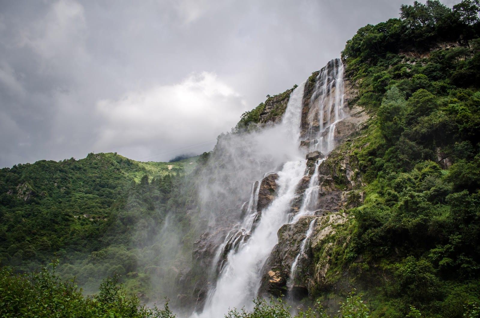
Near Jang, see Nuranang falls, about 100 m high. The army's Warrior Cafe nearby serves tea, coffee, samosas and noodles. You reach Tawang by evening. Keep tonight very quiet. Rest, drink water and eat light.
Special Tips for This Day: Wear warm layers from the morning, a cap and gloves. Keep a flask of hot water in the car. At Jaswant Garh, remove your cap inside the shrine and speak softly. Morning light is best for photos of Nuranang falls. Do not let children run at Sela. A fall on ice is the biggest danger here.
Today you stay in Tawang, so the day is easy. After breakfast, go up to Tawang Monastery, called Gaden Namgyal Lhatse. Merak Lama Lodre Gyatso founded it in 1680 to 1681, at the wish of the 5th Dalai Lama. It is the largest Buddhist monastery in India. Inside the Dukhang, the main prayer hall, sits a tall gilded Buddha. A small museum stands near the back gate.
Go early, when the monks gather for morning prayers. Sit quietly at the back and listen. Then drive to the Urgelling Monastery, founded in the late 1480s by Lama Urgen Sangpo. The 6th Dalai Lama, Tsangyang Gyatso, was born here in 1683.
After lunch, our driver files your Bum La permit at the DC office, in working hours. Then rest at the hotel. Your body is still getting used to the height.
In the late afternoon, visit the Tawang War Memorial. It honours the 2,420 soldiers who died in the 1962 war. Their names and regiments are written on the memorial, beside the Namgyal Chorten. The memorial is open from 7:45 am to 6 pm. Stay for the sound and light show if it runs that evening.
Special Tips for This Day: Dress modestly for the monastery, with shoulders and knees covered. Remove shoes where asked. Do not point your feet at the altar when you sit. Carry small notes for offerings. If anyone has a headache today, skip Urgelling and rest. Bum La tomorrow is higher.
Today you go to the border. Leave after an early breakfast, with your permit stamped at the army cantonment. The road to Bum La is about 37 km, but it is rough and slow. Only SUVs are advised, and only on clear days. Plan the whole day for it.
On the way, you may pass PT Tso and other small lakes. In winter they freeze. Please never step on the ice.
Bum La is at about 4,600 m. The army guides visitors here. Listen to the soldiers and follow every instruction. Photography rules are set by the army on the day. You will feel the cold and the thin air, so stay only as long as you are comfortable.
On the way back, stop at Sangetsar lake, at about 3,708 m. An earthquake blocked the stream here and formed the lake. Families call it Madhuri lake, after a film song shot here. The army runs the small Shungatser Cafe beside it. Have a hot drink and sit for a while. You reach Tawang by evening.
Special Tips for This Day: Wear every warm layer you have, with a cap, gloves and sunglasses. Snow light is strong. Carry your eILP, the Bum La permit and your photo ID. Elders with heart or lung trouble, or anyone unwell at breakfast, should skip Bum La and visit only the nearer lakes. If the army closes the road, we use tomorrow morning or keep the day for Tawang town.
Today you start your journey home. Leave Tawang after breakfast. You cross Jang and Sela again, or take the tunnel. If you missed Nuranang falls on Day 3, stop there now.
The drive to Bomdila is about 165 to 185 km, and takes about 7 to 8 hours. As you come down, the air gets thicker, and most people feel lighter and sleep better.
If you reach Bomdila before 4 pm, visit the Upper Gompa on the hilltop, which has a school for young monks.
In the evening, walk in the Bomdila market. Have momos and a hot cup of tea, and sleep early. Tomorrow is a long day to Guwahati.
Special Tips for This Day: Keep your warm jacket in the car, not in the boot, because Sela is cold even on the way down. Give elders the front seat today. If you feel car-sick, look at the horizon and keep a window a little open. Fill the water bottles before you leave Tawang.
Today you drive out of the mountains. Leave Bomdila by about 7 am. You come down through Tenga and past Bhalukpong, and then into the Assam plains.
The drive to Guwahati is about 320 to 340 km. With stops, it takes about 8 to 10 hours. This is the longest day, but the last part is on flat road.
If you are not tired, stop at the army's Ball of Fire Museum in the Tenga valley. It tells the story of the 5th Mountain Division and the brave soldiers of 1962.
You reach Guwahati by evening. Check in, have a good hot bath and a proper dinner. Rest well. Tomorrow morning is for Maa Kamakhya.
Special Tips for This Day: Keep snacks and water within reach, as long stretches have few good stops. Elders should get out and walk for five minutes every two hours. Share your live location with family at home on this long day. Charge your phone and power bank the night before.
Today you take darshan of Maa Kamakhya before you fly home. The temple stands on Nilachal hill in Guwahati. Go early in the morning, as the queues grow fast through the day.
Please check the temple's timings for your date before you go. Every June, during the Ambubachi Mela, the temple doors close for about four days. In 2024 they closed from 22 June and opened for darshan on 26 June.
After darshan, come back to the hotel for breakfast and check out. Our driver drops you at the airport or the station.
If you have more days, you can stay on in Assam. See our Kaziranga National Park tour for the rhinos, or the Guwahati Shillong Cherrapunjee tour for Meghalaya.
Special Tips for This Day: Wear simple, modest clothes for the temple. Leave phones and bags with a family member or in the car if the temple does not allow them inside. Carry a water bottle for the queue. Elders should ask about any separate queue for senior citizens at the temple office.
Travel tips
On this trip you climb slowly from the Kameng river at Bhalukpong to Dirang, cross Sela Pass, pray at Tawang Monastery, stand at Bum La on the border, and end with darshan of Maa Kamakhya in Guwahati. Here is everything you should know before you go, and while you travel.
Every visitor needs a permit. Indian citizens apply for the tourist eILP on eilp.arunachal.gov.in. Foreign nationals, including OCI card holders, need a Protected Area Permit.
An OCI card holder has a foreign passport and needs the PAP. If you live abroad on an Indian passport, the eILP is meant for Indian citizens, but the Arunachal Police page asks NRIs to apply for a protected area permit. Tell us early, and we will confirm the rule for your family.
Bum La is about 37 km from Tawang, at about 4,600 m. You need a special permit from the DC office in Tawang, stamped by the army.
Our driver files your papers the day you reach Tawang. If the army closes the road, we keep the day for the lakes near town and try again the next morning. The army decides, and we follow.
Sela Pass is at about 4,200 m. The Sela Tunnel, opened on 9 March 2024, runs about 400 m below it as an all-weather link to Tawang.
Please talk to us before you book. We add a spare day and keep the plan flexible, or suggest a better month.
Altitude sickness can start at about 2,500 m. Tawang is about 3,000 m or more, Sela about 4,200 m and Bum La about 4,600 m.
The Tawang district says a helicopter runs from Guwahati airport to the Tawang helipad in about 55 to 60 minutes, on fixed days and in clear weather. It can help elders, but keep a backup day.
The easiest months are October to early December and March to May. Avoid June to September if you can.
Try thukpa, momos, zan, khura and gyapa khazi. Buy Monpa handmade paper in Tawang.
The army runs the Warrior Cafe near Nuranang, with tea, coffee, samosas and noodles, and the Shungatser Cafe at Sangetsar lake, which needs a permit.
Tawang is the west of the state. Ziro and Parshuram Kund need their own roads and their own days.
Your eILP must list every place you plan to visit. Tell us the full plan before we apply.
Om Mani Padme Hum
In Tawang you will see these words on many prayer wheels. Monks and Monpa families turn the wheels as they walk, clockwise. Turn one slowly on your last morning at the monastery. Then go down the mountain with a quiet mind, and take darshan of Maa Kamakhya before you fly home.
What's included
What travellers say
“Had a wonderful experience with way to india for my badrinath kedarnath yatra.everything was well organized-from travel accommodation to food. A special thanks to Ms. Neha who managed everything so beautifully n was extremely supportive n cooperative throughout the journey. They took great care of us n darshan was done very smoothly.”3 weeks ago · Google
“A big thanks to Way To India for organising such a truly memorable and spiritually fulfilling experience during our 12 Jyotirlinga Darshan pilgrimage from 1st May to 18th May. They organized the entire journey exceptionally well, ensuring that every aspect of the trip was smooth, comfortable, and hassle-free. From transportation and hotel arrangements to darshan planning and coordination, everything was managed professionally. Despite the extensive travel across multiple destinations, the itinerary was well-structured, allowing us to complete all the Jyotirlinga darshans comfortably. Thanks to staff of Way To India, especially, Ms Neha, who was supportive, responsive, and attentive throughout the journey, always ready to assist whenever needed. Her dedication and careful planning made this sacred pilgrimage stress-free and enjoyable. I sincerely appreciate their excellent service, commitment, and hospitality. Highly recommend Way To India to anyone planning a spiritual tour, especially for the 12 Jyotirlinga Yatra. Thank you for making this divine journey so special and memorable.”4 months ago · Google
“We have successfully completed the 12 Jyotirlinga Yatra, with Waytoindia and it was a truly blessed and unforgettable journey. Every aspect of the tour was well planned and professionally organized, from transportation and accommodations to temple visits and sightseeing. Visiting all twelve sacred Jyotirlingas was a deeply spiritual experience. The itinerary was designed efficiently, allowing us to have darshan at each shrine comfortably while enjoying the cultural and religious significance of every destination. We sincerely appreciate the excellent support and coordination throughout the trip. The team was always available to assist, ensuring a smooth and stress-free pilgrimage. Thank you Waytoindia for making our dream of completing the 12 Jyotirlinga Yatra a reality. We highly recommend this tour to anyone seeking a well-organized and spiritually enriching pilgrimage experience. Har Har Mahadev! 🙏🕉️”5 months ago · Google
Travelled with Way to India?
Share your experience on Google — it takes a minute and helps fellow travellers plan with confidence.
FAQ
For the Tawang road from Guwahati, 7 nights and 8 days is the right length. You need two nights on the way up to climb slowly, three nights in Tawang for the monastery and Bum La, and two nights coming down. With fewer days, you lose Bum La or rush the altitude.
Yes. Indian citizens need an Inner Line Permit. Tourists apply online on the official portal, eilp.arunachal.gov.in. The tourist eILP covers a stay of up to 14 days. Children under 14 do not need their own eILP, but must travel with an adult. Carry a printout and your photo ID, as it is checked at Bhalukpong.
Yes, with a Protected Area Permit. The state tourism department says foreigners apply through an approved local tour operator and pay a royalty per person. OCI card holders have a foreign passport, so they also need this permit. Citizens of Pakistan, Bangladesh, China and Myanmar need Home Ministry clearance.
You apply at the Office of the Deputy Commissioner in Tawang, in working hours. The permit is then stamped at the army cantonment in Tawang. From 1 September 2025, an entry fee is charged at the time of issue. The army can close the road for weather or duty.
The top of Sela Pass, at about 4,200 m, can close after heavy snow. Since 9 March 2024, the Sela Tunnel runs about 400 m below the pass. The Tawang district calls it an all-weather link to Tawang. In snow, drivers should use non-skid chains.
October to early December and March to May are the easiest months for the Tawang road. December to February brings snow and frozen lakes. June to September is the monsoon, when landslides often block the road. For the Ziro Festival of Music, go in late September.
Yes, with care. Tawang is at about 3,000 m or more, and altitude sickness can start at about 2,500 m. Elders should climb slowly, rest on arrival and skip Bum La if unwell. Anyone with heart or lung trouble should ask their own doctor before booking.
By road, you go through Bhalukpong, Bomdila, Dirang, Sela Pass and Jang. The Tawang district says the full drive takes 14 to 16 hours, so most people break it at Bhalukpong and Dirang. There is also a helicopter from Guwahati airport, about 55 to 60 minutes, on fixed days in clear weather.
Sangetsar lake is about 35 km north of Tawang, at about 3,708 m. An earthquake blocked the stream and formed it. People call it Madhuri lake because a film song with Madhuri Dixit was shot there. You need army permission to visit.
Yes, but Ziro is on a different road. Ziro is about 115 km from Itanagar and is the home of the Apatani people. The Ziro Festival of Music usually happens in late September. Add three or four days, and include Ziro in your eILP when you apply.
Parshuram Kund is a Hindu tirth on the Lohit river in Lohit district, in eastern Arunachal. Devotees believe Lord Parshuram washed away his sin here. Thousands take a holy dip on Makar Sankranti. The nearest airports are Tezu and Dibrugarh, so it needs its own trip.
Yes. Carry enough cash for food, tips and small shopping. During landslides and bad weather, ATMs and digital payments can stop working, and mobile networks can drop on the high road. Download offline maps and share your route with family.
Before you book
You may also like
 7D / 6N
 4D / 3N
 7D / 6N6D / 5N
 6D / 5N
 5D / 4N
Tell us your dates and group size. A WayToIndia travel expert replies within a few hours with a plan you can customise freely. Planning India journeys since 2010.
Explore Way to India
© 2026 Way to India. All rights reserved.